Outsource Geospatial Services
Geospatial information collected by satellites, UAVs, and LIDAR often contains inconsistent spatial datasets, misaligned coordinate systems, and unreliable terrain models that impact downstream design accuracy.
IndiaCADworks’ geospatial services apply controlled processing pipelines, LiDAR and photogrammetry workflows, and spatial database structuring to convert raw data into engineering-grade outputs.
This results in optimized geospatial intelligence, supporting planning decisions, reducing rework, and enhancing output quality across civil and Infrastructure projects.
Geospatial Services We Offer
ICW provides geospatial data processing services aligned with recognized technical standards, including ISO, ANSI, BS 8888, and CSA frameworks.
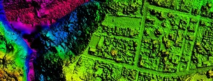
We use high-speed imaging and remote sensing to produce highway corridor mapping, updated Planimetric features, and orthophotography.
We produce base map layers for GIS products and full-color orthophotos of geometrically corrected features, such as bridges and overpasses, for use by mapping agencies.
Mapping
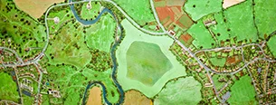
We specialize in capturing natural and man-made features for comprehensive GIS solutions or for individual projects.

We prepare detailed topographic maps showing geospatial disposition of utility companies’ assets and consumer indexing, and we update older topographic maps.
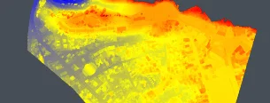
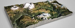
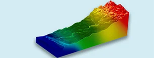
We process elevation datasets to generate accurate surface models for analytical use, supporting slope analysis, watershed modeling, and flood risk assessment for planning and environmental evaluation.
Modeling
We transform terrain data into engineering-ready models for design and execution, enabling cut-and-fill calculations and landslide susceptibility analysis to support infrastructure planning and risk assessment.
Mapping
We process LiDAR point cloud data through classification, ground/non-ground filtering, DTM/DSM generation, contour extraction, and 3D terrain modeling to produce accurate, engineering-ready terrain datasets.

We understand every aspect of GIS design, including software and hardware requirements, to ensure the delivery of highly accurate GIS Base Maps and “GIS-friendly” products.
We perform computerization of land surveys, scanning, georeferencing vectorization, plotting and proof reading of old hard copy records.

Image, video, map, vector, and LiDAR annotations delivering AI-ready geospatial data for detection, classification, and infrastructure mapping.
Geospatial Data Processing Workflow
Geospatial datasets are processed through a controlled pipeline to ensure alignment, usability, and integration with engineering and GIS systems.
- Data Acquisition: Satellite, UAV, aerial, and LiDAR datasets are sourced based on project requirements.
- Preprocessing & Calibration: Through cleaning, normalization, and calibration, the data have been processed to address inconsistencies and prepare for downstream processing.
- Georeferencing & Alignment: Datasets are rectified to defined coordinate systems to ensure spatial accuracy and consistency.
- Feature Extraction: Key elements such as infrastructure, terrain, and land-use features are digitized into structured vector layers.
- Spatial Analysis: Datasets are analyzed for terrain evaluation, infrastructure mapping, and spatial pattern assessment.
- GIS Database Structuring: Spatial data is organized into schema-driven GIS databases with defined attributes and metadata.
- Output & Delivery: Deliverables are prepared as GIS layers, elevation models, CAD-ready datasets, or web-enabled formats aligned to project requirements.
Geospatial Software and Technology Stack
ICW utilizes industry-standard geospatial software and processing tools to support photogrammetry, remote sensing, LiDAR processing, and GIS database development.
GIS Software
- ArcGIS
- ArcGIS Pro
- QGIS
- ERDAS Imagine
- Agisoft Metashape
- MicroStation Bentley (TerraScan, TerraModel)
- DroneDeploy
- AutoCAD Civil 3D
Photogrammetry Tools
- Agisoft Metashape
- Pix4D
LiDAR Processing
- LAStools
- TerraScan
Remote Sensing and Image Processing
- ERDAS Imagine
- ENVI
Geospatial Processing - Key Takeaways
ICW provides structured geospatial processing support through defined workflows, validated data-processing environments, and controlled quality-verification procedures.
- Seamless GIS-CAD-BIM Integration: Facilitates GIS-to-CAD data conversion, point cloud-to-BIM modeling, and terrain modeling integration.
- Multi-Format Data Delivery: Supports Shapefile (.shp), GeoJSON, KML/KMZ, Geodatabases (.gdb), LAS/LAZ point clouds, and GeoTIFF formats for seamless integration across GIS, LiDAR, and engineering systems.
- Accuracy & Quality Assurance Framework: Checks output accuracy against positional accuracy requirements, defined RMSE thresholds, image resolution requirements, LiDAR point density requirements, and topology.
- Real-Time Geospatial Decision Enablement: Provides users access to interactive web maps, spatial dashboards, and API access to geospatial data in real time, allowing infrastructure project decision-making, coordination, and execution to take place in less time.
- Scalable Spatial Data Architecture: Organizes all geospatial data in a structured way to improve spatial indexing and query performance using PostGIS or enterprise geodatabases.
Discuss Your Geospatial Processing Requirements
Organizations considering outsourced geospatial services can get in touch with ICW to understand their needs, including project scope, data sources, data accuracy, and output types.
Frequently Asked Questions
Parallel workflows and data pipelines are used to process high-volume datasets, ensuring the timely delivery of results regardless of project scale.
Satellite, UAV, and LiDAR data sources are standardized through calibration, coordinate systems, and the structuring of the data schema.
The management of revisions is controlled through a version-tracking mechanism that ensures updates are versioned, validated, and aligned with the latest requirements.
The structure is achieved through structured GIS database schemas that include attributes and indexing.
Yes, datasets can be configured for integration with web-based dashboards and mapping platforms to support ongoing monitoring and stakeholder visibility.
Data handling follows controlled-access, secure-transfer protocols, and project-specific confidentiality requirements to protect sensitive spatial information.