GIS Labelling and Annotation Services
IndiaCADworks enables organizations to optimize geospatial intelligence through precision-focused GIS Annotation workflows, converting raw imagery, LiDAR scans, and CAD layers into AI-compatible, analysis-grade datasets. As part of our Core Geospatial Data Services, these annotation pipelines form the Data Enrichment layer. They elevate LiDAR, photogrammetric, and orthophotography inputs into engineering-grade datasets ready for advanced modeling and predictive analysis.
With more than two decades of demonstrated global success, IndiaCADworks provides statistically validated, RMSE-benchmarked spatial datasets that power better forecasting accuracy, resource allocation, and asset planning in infrastructure, smart city, and environmental analytics. By integrating rule-based automation with expert-supervised validation, we ensure over 98% annotation precision, full GDPR/SOC2 compliance, and seamless interoperability with leading GIS tools and enterprise data ecosystems.
-
Need a Custom Quote?
- Contact Form
- Live Chat
- Email Us
- 855-259-3709
Core GIS Annotation Services
Our GIS Annotation offerings are designed for organizations that depend on accurate, high-volume spatial data for analytics and automation. Every workflow is custom-built to your operational and compliance goals.
We convert raw geospatial inputs, such as DTM/DEM, elevation models, and satellite imagery, into semantically rich, labeled datasets optimized for analysis, AI training, and spatial modeling, thereby bridging the gap between data acquisition and decision intelligence across various industries.
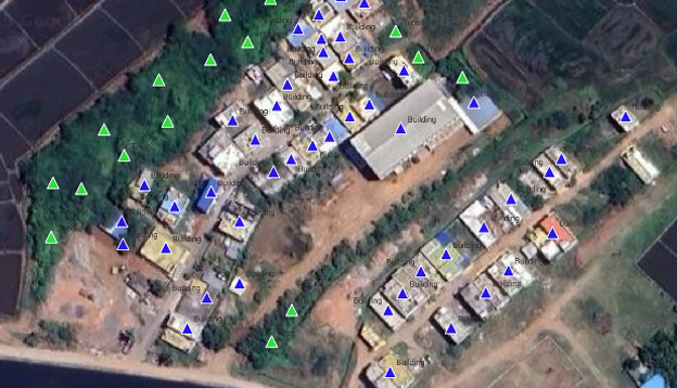
1. Image Annotation
We annotate 2D satellite, aerial, and drone imagery to map, classify, and quantify spatial observations for AI/ML-powered GIS applications. Each of the workflows supports semantic segmentation, object detection, and feature classification tasks across multi-resolution geospatial datasets, ensuring consistency and accuracy in labeling for downstream spatial analysis and modeling.
Applications:
- Urban zoning and infrastructure planning
- Agricultural yield tracking and environmental monitoring
- AI-ready imagery generation for geospatial and remote sensing models
Deliverables:
COCO, Pascal VOC, and GeoTIFF datasets optimized for direct integration with TensorFlow, PyTorch, and other AI/ML pipelines.
2. Video Annotation
We annotate drone, aerial, and ground-based videos frame by frame to create motion-aware, AI-ready datasets for autonomous navigation, surveillance, and behavioral analytics platforms. Our annotation combines AI-accelerated pre-labeling with precise human validation to maintain temporal consistency and spatial integrity across thousands of frames.
Applications:
- Real-time traffic flow and route optimization
- Asset tracking and compliance monitoring
- Behavioral analysis and surveillance modeling
Deliverables:
JSON, CVAT, or YOLO-compatible outputs suitable for real-time GIS analysis, traffic modeling, and AI-based video analytics.
3. LiDAR and Point Cloud Annotation
We transform raw LiDAR scans into 3D-ready datasets by segmenting millions of spatial points to identify terrain, vegetation, and built infrastructure. Each dataset undergoes precision registration, denoising, and RMSE validation to ensure high spatial fidelity, making it ideal for topographic modeling and digital twin creation.
Applications:
- Digital twin development and infrastructure maintenance
- Topographic and elevation mapping
- Asset planning and spatial change analysis
Deliverables:
High-quality DTM/DSM models, semantic segmentation layers, and classified 3D point clouds delivered in LAS, LAZ, or GeoTIFF formats.
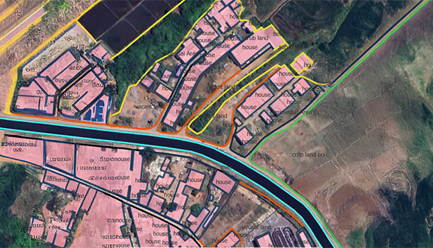
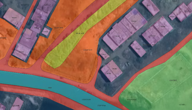
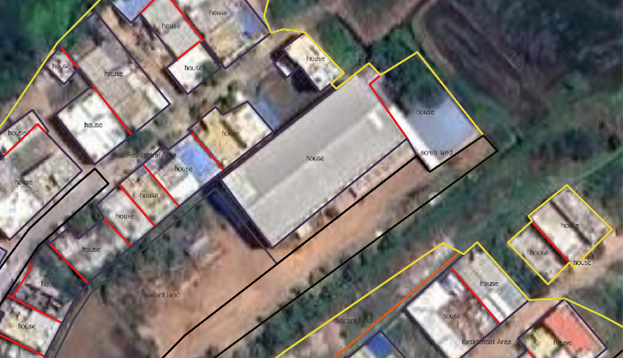
4. Map and Vector Annotation
We annotate and refine vector datasets (SHP, DXF, GeoJSON) to establish accurate land boundaries, parcels, and network topologies. The workflow includes raster-to-vector conversion, shapefile generation, and attribute tagging to ensure interoperability across GIS and CAD ecosystems.
Applications:
- Land parcel mapping and topographic zoning for real estate and planning
- Utility and transportation network mapping for asset visibility
- Environmental and regulatory compliance analysis
Deliverables:
Validated shapefiles, DXF layers, and GeoJSON datasets with integrated topology checks and attribute tagging, compatible with ArcGIS and Mapbox ecosystems.
5. Customized Annotation Workflows
Each project is customized to the client's goals, compliance standards, and data volumes. Workflows integrate AI-assisted pre-labeling, Python automation, and cloud-based dashboards to improve throughput and maintain consistency across orthophoto production, terrain modeling, and map digitization.
Applications:
- End-to-end automation for high-volume annotation projects
- Data harmonization across photogrammetry, LiDAR, and CAD inputs
- GIS dataset preparation for AI/ML model training
Deliverables:
Automated scripts (Python, GDAL), audit dashboards, and compliance-ready annotation outputs with embedded QC metadata.
6. Accuracy Validation
All GIS annotation projects follow a three-tier QC framework that combines automated, manual, and statistical validation to ensure geometric accuracy and labeling precision. Validation includes GCP alignment, RMSE scoring, and precision–recall analysis to verify data integrity.
Applications:
- Quality benchmarking for AI/ML model datasets
- Spatial accuracy validation for enterprise GIS systems
- Regulatory and compliance audits for spatial data
Deliverables:
Comprehensive QC logs, confusion matrices, accuracy reports, and GCP alignment certificates verifying 98–99% annotation accuracy.
Tools Used
We leverage a robust suite of industry-standard tools and platforms to perform high-precision GIS annotation and labeling across 2D, 3D, and video datasets.
Desktop GIS & Remote Sensing Software
- QGIS
- ArcGIS
- ERDAS Imagine
- AutoCAD Map 3D
- Global Mapper
- CloudCompare
- 3DReshaper
- AutoCAD Civil 3D
Annotation & Labeling Platforms
- ArcGIS Video Server
- LabelBox
- CVAT
Web & Cloud GIS Tools
- Mapbox API
- ArcGIS REST API
- Cloud-based GIS dashboards (AWS, Azure)
Scripting & Automation
- Python (including validation scripts)
- GDAL
Compliance & Data Security
- SOC2/GDPR-certified data environments
Accuracy Assessment
- QGIS Accuracy Assessment Plugins
Who We Serve — Industry Applications
Urban Planning and Smart Cities
- We support planners and engineers with GIS annotations that inform data-driven zoning and design.
- Use cases – Land-use classification, population density analysis, and predictive urban modeling.
- Outcome –Faster insights, smarter city design, sustainable planning.
Infrastructure and Utilities
- We help telecom, oil & gas, and energy firms see their networks end-to-end.
- Data labeled – Underground utilities, transmission lines, substations, and road networks.
- Outcome – Reduced downtime and better maintenance visibility.
Our Point Cloud Annotation services and GIS solutions enable cross-platform visibility for asset management and predictive infrastructure analytics.
Environmental Monitoring
- We annotate satellite imagery for crop health, deforestation, and disaster analysis.
- Outcome – Actionable sustainability insights that help organizations respond quickly and allocate resources effectively.
Security and Surveillance
- From factory floors to logistic yards, we label motion and behavior data for real-time awareness.
- Outcome – AI-trained video models that cut monitoring time and strengthen safety compliance.
-
Need Pricing Details?
- Contact Form
- Live Chat
- Email Us
- 855-259-3709
Why Partner with IndiaCADworks
| Capability | Our Advantage |
|---|---|
| Experience | 20+ years in GIS and CAD services |
| Accuracy | 98%+ precision validated via multi-level QC |
| Scalability | Enterprise-level annotation capacity |
| Compliance | 100% GDPR/SOC2 certified |
| Technology | GIS + AI toolchain expertise |
Build AI-Ready Spatial Intelligence with IndiaCADworks
We have collaborated with international agencies, infrastructure companies, and environmental organizations—consistently providing annotation accuracy, pace, and integrity at enterprise levels.
Validate accuracy, speed, and ROI—and discover how IndiaCADworks turns raw data into strategic intelligence through GIS Annotation and scalable GIS applications that transform operations.
Start with a no-risk pilot now.
-
Start with a Free Trial?
- Contact Form
- Live Chat
- Email Us
- 855-259-3709

Frequently Asked Questions
We handle imagery, video, vector, and LiDAR datasets — delivering Point Cloud Annotation, raster segmentation, and multi-layer vector outputs.
We maintain 98–99% accuracy using automated validation, manual QC, and RMSE-based accuracy testing.
QGIS, ArcGIS, AutoCAD Map 3D, ERDAS Imagine, and CloudCompare, integrated with AI pre-labeling frameworks.
Yes, we’ve delivered datasets with over 10 million annotations, leveraging cloud infrastructure and distributed teams.
Utilities, urban planning, transportation, and environmental agencies — sectors dependent on spatial accuracy and GIS analysis.
All workflows adhere to GDPR and SOC2 standards, utilizing encrypted file handling and robust access controls.
3–5 business days for 1,000 images or 1 hour of video, depending on dataset complexity.
Yes — we offer proof-of-concept pilots to validate accuracy, turnaround time, and output formats.
